Geomatics integrates advanced technologies such as GPS, remote sensing, and GIS to collect, analyze, and manage spatial data, offering comprehensive solutions for land surveying and environmental monitoring. Cartography focuses on the art and science of map-making, emphasizing design principles and visual representation to effectively communicate spatial information. Explore further to understand the distinct roles and applications of Geomatics and Cartography in geographic sciences.
Main Difference
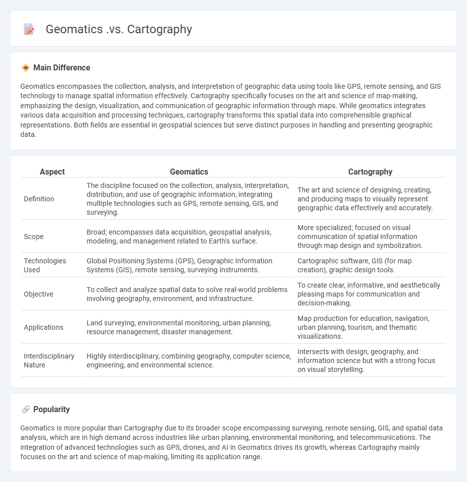
Geomatics encompasses the collection, analysis, and interpretation of geographic data using tools like GPS, remote sensing, and GIS technology to manage spatial information effectively. Cartography specifically focuses on the art and science of map-making, emphasizing the design, visualization, and communication of geographic information through maps. While geomatics integrates various data acquisition and processing techniques, cartography transforms this spatial data into comprehensible graphical representations. Both fields are essential in geospatial sciences but serve distinct purposes in handling and presenting geographic data.
Connection
Geomatics encompasses the collection, analysis, and interpretation of geospatial data, forming the foundational discipline for cartography. Cartography specializes in the graphical representation of this data through maps, utilizing techniques from geomatics to ensure accuracy and spatial relevance. The integration of geomatics technologies such as GPS, remote sensing, and GIS directly enhances the precision and detail of cartographic outputs.
Comparison Table
| Aspect | Geomatics | Cartography |
|---|---|---|
| Definition | The discipline focused on the collection, analysis, interpretation, distribution, and use of geographic information, integrating multiple technologies such as GPS, remote sensing, GIS, and surveying. | The art and science of designing, creating, and producing maps to visually represent geographic data effectively and accurately. |
| Scope | Broad; encompasses data acquisition, geospatial analysis, modeling, and management related to Earth's surface. | More specialized; focused on visual communication of spatial information through map design and symbolization. |
| Technologies Used | Global Positioning Systems (GPS), Geographic Information Systems (GIS), remote sensing, surveying instruments. | Cartographic software, GIS (for map creation), graphic design tools. |
| Objective | To collect and analyze spatial data to solve real-world problems involving geography, environment, and infrastructure. | To create clear, informative, and aesthetically pleasing maps for communication and decision-making. |
| Applications | Land surveying, environmental monitoring, urban planning, resource management, disaster management. | Map production for education, navigation, urban planning, tourism, and thematic visualizations. |
| Interdisciplinary Nature | Highly interdisciplinary, combining geography, computer science, engineering, and environmental science. | Intersects with design, geography, and information science but with a strong focus on visual storytelling. |
Spatial Data
Spatial data, also known as geospatial data, refers to information that describes the location and shape of objects on Earth's surface, often represented by coordinates such as latitude and longitude. It is used extensively in Geographic Information Systems (GIS) for mapping, analysis, and visualization of geographic phenomena. Applications span urban planning, environmental monitoring, transportation logistics, and disaster management. Accurate spatial data collection involves technologies like GPS, remote sensing, and LiDAR, ensuring precise geographic referencing and analysis.
Geospatial Technologies
Geospatial technologies encompass tools like Geographic Information Systems (GIS), remote sensing, and Global Positioning Systems (GPS) that capture, analyze, and visualize spatial data. These technologies support diverse applications, including urban planning, environmental monitoring, disaster management, and agriculture precision. The global geospatial analytics market is projected to reach USD 134.4 billion by 2028, driven by increasing demand for location-based services and smart city initiatives. Integration of artificial intelligence enhances the accuracy and efficiency of geospatial data interpretation across industries.
Mapping Techniques
Mapping techniques encompass methods such as thematic mapping, topographic mapping, and cadastral mapping, crucial for geographical data visualization and analysis. Geographic Information Systems (GIS) enable the integration and interpretation of spatial data, improving decision-making in urban planning and environmental management. Remote sensing technologies, including satellite imagery and drone surveys, enhance accuracy and detail in map creation. Advances in cartographic design principles ensure maps are both informative and user-friendly, supporting applications across disciplines.
Surveying
Surveying is a critical process in civil engineering, construction, and land development used to measure and map the Earth's surface accurately. It involves techniques such as GPS, total stations, and laser scanning to determine precise locations, elevations, and boundaries. Modern surveying relies heavily on Geographic Information Systems (GIS) to analyze spatial data and create detailed maps for urban planning and infrastructure projects. This discipline ensures accurate property delineation, supports environmental assessments, and facilitates the efficient design of transportation networks.
Data Visualization
Data visualization transforms complex datasets into graphical representations such as charts, graphs, and maps, enabling intuitive understanding and faster decision-making. Popular tools like Tableau, Power BI, and D3.js facilitate the creation of interactive dashboards, enhancing business intelligence across industries. Effective data visualization highlights key trends, outliers, and patterns, improving communication among stakeholders. Visual analytics supports data-driven strategies by making large volumes of information accessible and actionable.
Source and External Links
Geomatics Overview - Geomatics involves a wide range of methods and technologies for collecting, managing, and analyzing data about Earth and includes Geographic Information Systems (GIS) and cartography.
Geomatics Wikipedia - Geomatics includes the tools and techniques used in land surveying, remote sensing, cartography, and geographic information systems (GIS).
Cartography and GIS - Cartography is the art of creating maps, dealing with interpreted data, and using GIS to visualize and analyze spatial data.
FAQs
What is geomatics?
Geomatics is the discipline that involves the collection, analysis, interpretation, and management of geographic data using technologies like surveying, GPS, remote sensing, and geographic information systems (GIS).
What is cartography?
Cartography is the science and art of creating maps, involving the design, production, and study of spatial representations of geographic information.
How does geomatics differ from cartography?
Geomatics integrates data collection, analysis, and management of geographic information using technologies like GPS, GIS, and remote sensing, while cartography focuses specifically on the art and science of map design and production.
What are the main components of geomatics?
The main components of geomatics include surveying, geographic information systems (GIS), remote sensing, global positioning systems (GPS), cartography, and spatial data analysis.
What are the key functions of cartography?
Cartography primarily functions to collect, analyze, visualize, and communicate spatial data through maps, facilitating geographic understanding, navigation, spatial decision-making, and resource management.
What technologies are used in geomatics?
Geomatics uses technologies such as Geographic Information Systems (GIS), Global Positioning System (GPS), remote sensing, LiDAR, photogrammetry, and total stations.
Why are geomatics and cartography important today?
Geomatics and cartography are crucial today for accurate spatial data collection, geographic analysis, urban planning, environmental management, and navigation systems.