Geomorphology focuses on the scientific study of landforms, their processes, and the Earth's surface evolution, while geography encompasses a broader examination of the Earth's landscapes, environments, and human interactions. Geomorphologists analyze physical terrain features like mountains, valleys, and rivers, using techniques in geology and hydrology, whereas geographers integrate spatial data on both natural and human phenomena for comprehensive environmental understanding. Explore the distinctions and connections between these disciplines to deepen your insight into Earth's dynamic systems.
Main Difference
Geomorphology focuses on the study of Earth's landforms, their processes, history, and structure, examining physical features like mountains, valleys, and plains. Geography explores the spatial relationships and patterns between natural environments and human societies, incorporating physical, human, and environmental geography subfields. Geomorphology is a specialized branch of physical geography, emphasizing Earth's surface dynamics and landform evolution. Geography has a broader scope, integrating cultural, economic, political, and environmental aspects along with physical features.
Connection
Geomorphology, the scientific study of landforms and the processes shaping Earth's surface, directly supports geography by providing detailed insights into physical landscapes and terrain structures. Geographic analysis relies on geomorphological data to understand spatial patterns in topography, natural resource distribution, and environmental change. These interconnected fields enhance mapping accuracy, disaster management, and spatial planning through integrated physical and human geography perspectives.
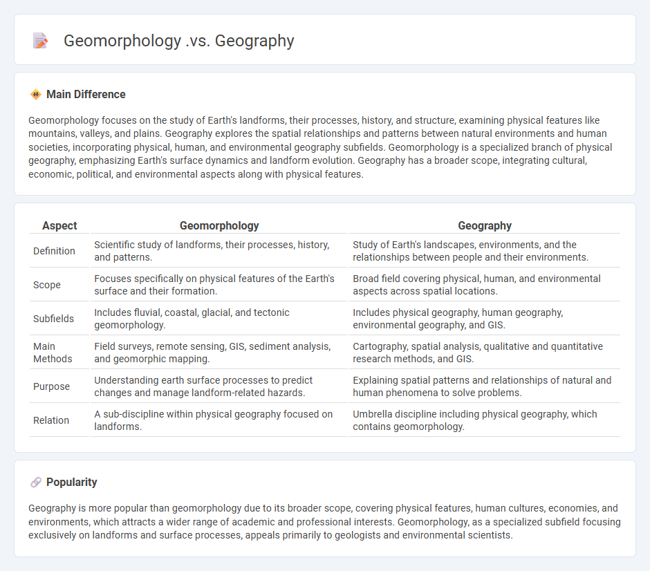
Comparison Table
| Aspect | Geomorphology | Geography |
|---|---|---|
| Definition | Scientific study of landforms, their processes, history, and patterns. | Study of Earth's landscapes, environments, and the relationships between people and their environments. |
| Scope | Focuses specifically on physical features of the Earth's surface and their formation. | Broad field covering physical, human, and environmental aspects across spatial locations. |
| Subfields | Includes fluvial, coastal, glacial, and tectonic geomorphology. | Includes physical geography, human geography, environmental geography, and GIS. |
| Main Methods | Field surveys, remote sensing, GIS, sediment analysis, and geomorphic mapping. | Cartography, spatial analysis, qualitative and quantitative research methods, and GIS. |
| Purpose | Understanding earth surface processes to predict changes and manage landform-related hazards. | Explaining spatial patterns and relationships of natural and human phenomena to solve problems. |
| Relation | A sub-discipline within physical geography focused on landforms. | Umbrella discipline including physical geography, which contains geomorphology. |
Landforms
Landforms represent the natural physical features of the Earth's surface, including mountains, valleys, plateaus, and plains. These structures result from geological processes such as tectonic activity, erosion, and sediment deposition. Mountains like the Himalayas formed through the collision of tectonic plates, while river valleys develop from the erosive power of flowing water. Understanding landforms is crucial for disciplines such as geology, geography, and environmental science.
Physical Processes
Physical processes involve natural phenomena governed by the laws of physics, such as heat transfer, fluid dynamics, and mechanical motion. These processes occur in various contexts, including atmospheric circulation, ocean currents, and geological formations. Understanding physical processes is crucial in fields like meteorology, engineering, and environmental science for modeling and predicting system behaviors. Accurate data acquisition and computational simulations enable detailed analysis of these dynamic interactions.
Spatial Analysis
Spatial analysis involves examining the locations, attributes, and relationships of features in spatial data using techniques like Geographic Information Systems (GIS), remote sensing, and spatial statistics. It enables the identification of patterns, trends, and correlations across geographic spaces, supporting decision-making in urban planning, environmental management, and transportation logistics. Common methods include spatial interpolation, cluster analysis, and network analysis to model geographic phenomena effectively. High-resolution satellite imagery and geospatial datasets enhance the accuracy and depth of spatial analysis applications worldwide.
Earth Surface
The Earth's surface is composed of approximately 71% water, primarily oceans, and 29% land, including continents and islands. Its topography features diverse landforms such as mountains, plains, plateaus, and deserts shaped by tectonic activity, erosion, and volcanic processes. The lithosphere interacts dynamically with the atmosphere and hydrosphere, influencing climate patterns and ecological systems. Major landmasses like Asia, Africa, and the Americas contain critical biomes that support biodiversity and human civilization.
Human-Environment Interaction
Human-environment interaction studies the ways humans adapt to and modify their natural surroundings, impacting ecosystems through activities such as agriculture, urbanization, and deforestation. This relationship is dynamic, with environmental changes influencing human behavior and technological advancements in turn reshaping landscapes. Key concepts include sustainability, resource management, and environmental impact assessment, which are critical for addressing challenges like climate change and biodiversity loss. Understanding these interactions supports policies aimed at balancing development and conservation for future generations.
Source and External Links
Geomorphology | EBSCO Research Starters - Geomorphology is the scientific study of Earth's landforms, focusing on their formation, development, and influencing factors, often intersecting with geography and geology, while geography broadly studies Earth's environments and spatial relationships.
How to Become a Geomorphologist - Geomorphology bridges geography and geoscience, specifically studying individual landform features and the processes shaping them, whereas geography covers a wider scope including human-environmental interactions.
Geomorphology | Landforms, Processes, Erosion - Geomorphology is a scientific discipline focused on the description and classification of Earth's topographic features and the forces shaping them, while geography encompasses the study of Earth's landscapes, environments, and spatial phenomena more broadly.
FAQs
What is geography?
Geography is the scientific study of Earth's landscapes, environments, and the relationships between people and their environments.
What is geomorphology?
Geomorphology is the scientific study of landforms, their processes, history, and the interactions shaping Earth's surface.
How do geomorphology and geography differ?
Geomorphology focuses on the study of landforms, their processes, formation, and evolution, while geography encompasses the broader study of Earth's landscapes, environments, and spatial relationships, including both physical and human aspects.
What does geomorphology study?
Geomorphology studies the formation, evolution, and classification of landforms and the processes shaping Earth's surface.
What does geography focus on?
Geography focuses on the study of Earth's physical features, human societies, spatial relationships, and the interactions between the environment and human activities.
How are landforms analyzed in geomorphology?
Geomorphology analyzes landforms through spatial mapping, morphometric measurement, lithological study, tectonic assessment, and process-based modeling to understand their origin, evolution, and dynamics.
How is spatial data used in geography?
Spatial data in geography is used to map locations, analyze spatial relationships, model geographic phenomena, support urban planning, manage natural resources, and enhance decision-making through Geographic Information Systems (GIS).