Geomorphology studies the Earth's surface features and landforms, analyzing processes like erosion, sedimentation, and tectonic activity that shape landscapes over time. Hydrogeology focuses on the distribution, movement, and quality of groundwater within soil and rock formations, emphasizing aquifers and water resource management. Explore our detailed comparison to understand how these disciplines interconnect in environmental and geological sciences.
Main Difference
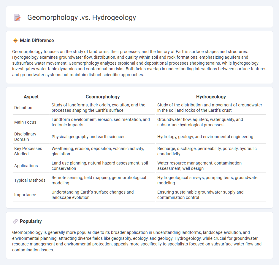
Geomorphology focuses on the study of landforms, their processes, and the history of Earth's surface shapes and structures. Hydrogeology examines groundwater flow, distribution, and quality within soil and rock formations, emphasizing aquifers and subsurface water movement. Geomorphology analyzes erosional and depositional processes shaping terrains, while hydrogeology investigates water table dynamics and contamination risks. Both fields overlap in understanding interactions between surface features and groundwater systems but maintain distinct scientific approaches.
Connection
Geomorphology examines the formation and evolution of landforms, which directly influence the distribution and movement of groundwater studied in hydrogeology. The shape and structure of terrain control recharge zones, aquifer characteristics, and flow patterns within hydrogeological systems. Understanding geomorphic features such as river valleys, hillslopes, and sediment deposits is essential for accurate groundwater modeling and resource management.
Comparison Table
| Aspect | Geomorphology | Hydrogeology |
|---|---|---|
| Definition | Study of landforms, their origin, evolution, and the processes shaping the Earth's surface | Study of the distribution and movement of groundwater in the soil and rocks of the Earth's crust |
| Main Focus | Landform development, erosion, sedimentation, and tectonic impacts | Groundwater flow, aquifers, water quality, and subsurface hydrological processes |
| Disciplinary Domain | Physical geography and earth sciences | Hydrology, geology, and environmental engineering |
| Key Processes Studied | Weathering, erosion, deposition, volcanic activity, glaciation | Recharge, discharge, permeability, porosity, hydraulic conductivity |
| Applications | Land use planning, natural hazard assessment, soil conservation | Water resource management, contamination assessment, well design |
| Typical Methods | Remote sensing, field mapping, geomorphological modeling | Hydrogeological surveys, pumping tests, groundwater modeling |
| Importance | Understanding Earth's surface changes and landscape evolution | Ensuring sustainable groundwater supply and contamination control |
Landforms
Landforms are natural physical features on the Earth's surface, including mountains, valleys, plateaus, and plains. These structures result from processes such as tectonic activity, erosion, and sediment deposition. Major mountain ranges like the Himalayas and Andes showcase tectonic uplift, while river valleys like the Grand Canyon demonstrate extensive erosion. Coastal landforms such as beaches and cliffs are continuously shaped by wave action and weathering.
Subsurface Water
Subsurface water refers to the water located beneath the earth's surface in soil pore spaces and rock formations. It includes groundwater stored in aquifers, which can supply wells, springs, and contribute to streamflow. Approximately 30% of the world's freshwater is held as groundwater, making it a critical resource for agriculture, drinking water, and industrial use. Monitoring subsurface water helps manage droughts, contamination, and sustainable water use.
Erosion Processes
Erosion processes involve the gradual removal of soil, rock, and sediment by natural forces such as water, wind, ice, and gravity. Key mechanisms include hydraulic action, abrasion, attrition, and corrosion, each contributing to landscape transformation over time. Rivers, glaciers, coastal waves, and aeolian winds represent primary agents driving erosion, reshaping terrains and influencing sediment deposition. Understanding erosion rates, influenced by factors like climate, vegetation cover, and land use, is essential for effective soil conservation and land management strategies.
Aquifer Systems
Aquifer systems consist of permeable rock or sediment layers capable of storing and transmitting groundwater, essential for water supply worldwide. Major aquifers such as the Ogallala Aquifer in the United States and the Guarani Aquifer in South America provide critical resources for agriculture, industry, and human consumption. The recharge rates, porosity, and permeability of these systems directly influence their sustainability and vulnerability to contamination. Monitoring aquifer levels using advanced hydrogeological methods ensures effective management and protection of these vital groundwater reserves.
Surface Dynamics
Surface dynamics examines the behavior and interactions of atoms and molecules at surfaces and interfaces, crucial for catalysis, material science, and nanotechnology. Techniques such as scanning tunneling microscopy (STM) and atomic force microscopy (AFM) enable real-time observation of surface reactions and morphological changes at the atomic scale. Understanding phenomena like adsorption, desorption, diffusion, and chemical reactions on surfaces supports advances in semiconductor fabrication, corrosion prevention, and energy storage technologies. Research in surface dynamics drives innovations in heterogeneous catalysis, improving efficiency in industrial chemical processes.
Source and External Links
Hydrogeomorphology - This field studies the interaction between hydrologic processes and landforms, including the impact of water on shaping landscapes.
Geomorphology and Its Application to Hydrogeology - This presentation explores how geomorphic features influence hydrology, including channel patterns and landforms that affect water flow.
Hydrology and Geomorphology - This lecture covers the basics of hydrology and geomorphology, discussing their interaction with landscapes, including glaciers and valleys.
FAQs
What is geomorphology?
Geomorphology is the scientific study of landforms, their processes, formation, and evolution of the Earth's surface.
What is hydrogeology?
Hydrogeology is the scientific study of the distribution, movement, and quality of groundwater in the Earth's subsurface.
How does geomorphology differ from hydrogeology?
Geomorphology studies landforms and surface processes shaping Earth's terrain, while hydrogeology focuses on groundwater distribution, movement, and quality within subsurface aquifers.
What are the main processes studied in geomorphology?
The main processes studied in geomorphology are weathering, erosion, transportation, and deposition of earth materials.
What is the focus of hydrogeology?
Hydrogeology focuses on the distribution, movement, and quality of groundwater in the Earth's subsurface.
How do landforms influence groundwater movement?
Landforms influence groundwater movement by affecting the direction, speed, and accumulation of water through variations in elevation, slope, and soil permeability.
Why are geomorphology and hydrogeology important for environmental studies?
Geomorphology and hydrogeology are crucial for environmental studies because geomorphology analyzes landforms and erosion processes impacting soil stability and habitat, while hydrogeology examines groundwater flow and quality essential for water resource management and contamination assessment.