Seismology is a specialized branch of geophysics focused on studying seismic waves to understand Earth's internal structure and earthquake dynamics. Geophysics encompasses a broader range of techniques, including gravity, magnetic, and electrical methods, to investigate Earth's physical properties and processes. Explore more to discover how these interconnected fields advance our knowledge of Earth.
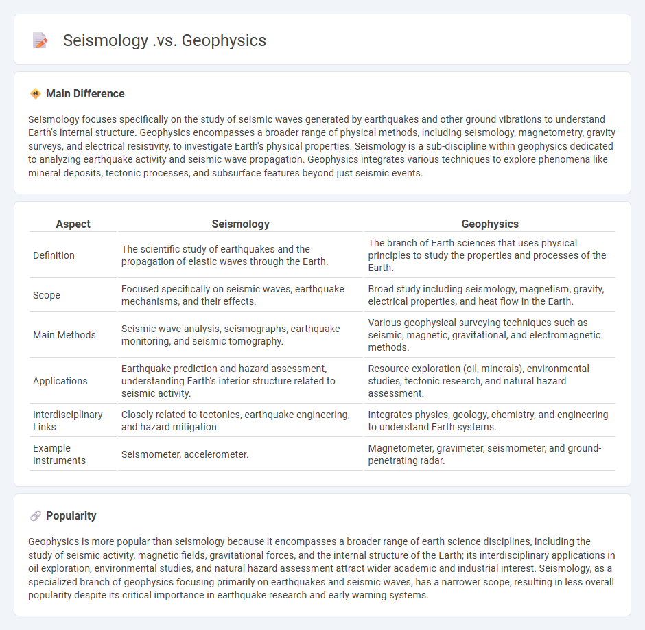
Main Difference
Seismology focuses specifically on the study of seismic waves generated by earthquakes and other ground vibrations to understand Earth's internal structure. Geophysics encompasses a broader range of physical methods, including seismology, magnetometry, gravity surveys, and electrical resistivity, to investigate Earth's physical properties. Seismology is a sub-discipline within geophysics dedicated to analyzing earthquake activity and seismic wave propagation. Geophysics integrates various techniques to explore phenomena like mineral deposits, tectonic processes, and subsurface features beyond just seismic events.
Connection
Seismology, a branch of geophysics, studies seismic waves generated by earthquakes and artificial sources to analyze Earth's internal structure. Geophysics employs seismic data alongside gravity, magnetic, and electrical methods to interpret subsurface properties and processes. These disciplines collectively enhance earthquake prediction, resource exploration, and geohazard assessment through integrated Earth system analysis.
Comparison Table
| Aspect | Seismology | Geophysics |
|---|---|---|
| Definition | The scientific study of earthquakes and the propagation of elastic waves through the Earth. | The branch of Earth sciences that uses physical principles to study the properties and processes of the Earth. |
| Scope | Focused specifically on seismic waves, earthquake mechanisms, and their effects. | Broad study including seismology, magnetism, gravity, electrical properties, and heat flow in the Earth. |
| Main Methods | Seismic wave analysis, seismographs, earthquake monitoring, and seismic tomography. | Various geophysical surveying techniques such as seismic, magnetic, gravitational, and electromagnetic methods. |
| Applications | Earthquake prediction and hazard assessment, understanding Earth's interior structure related to seismic activity. | Resource exploration (oil, minerals), environmental studies, tectonic research, and natural hazard assessment. |
| Interdisciplinary Links | Closely related to tectonics, earthquake engineering, and hazard mitigation. | Integrates physics, geology, chemistry, and engineering to understand Earth systems. |
| Example Instruments | Seismometer, accelerometer. | Magnetometer, gravimeter, seismometer, and ground-penetrating radar. |
Seismic Waves
Seismic waves are energy waves generated by the sudden release of stress in the Earth's crust, typically during earthquakes or volcanic eruptions. These waves travel through the Earth's interior and along its surface, classified mainly into body waves (P-waves and S-waves) and surface waves (Love waves and Rayleigh waves). P-waves are the fastest seismic waves and can move through solids, liquids, and gases, while S-waves are slower and only propagate through solids. The analysis of seismic wave velocity and behavior helps geologists determine the Earth's internal structure and locate earthquake epicenters.
Earth's Structure
Earth's structure consists of distinct layers: the crust, mantle, outer core, and inner core. The crust, varying between 5 to 70 kilometers thick, forms the planet's solid surface, while the mantle extends about 2,900 kilometers beneath it, composed of semi-solid rock facilitating tectonic movement. The outer core, made of liquid iron and nickel, surrounds the solid inner core, which measures approximately 1,220 kilometers in radius and generates Earth's magnetic field through its dynamic motions. Understanding these layers is essential for studying geological processes, seismic activity, and Earth's magnetic properties.
Geophysical Methods
Geophysical methods utilize physical principles to investigate subsurface properties through techniques such as seismic reflection, ground-penetrating radar, magnetometry, and electrical resistivity tomography. These methods enable the detection and mapping of geological structures, mineral deposits, groundwater reservoirs, and archaeological sites with minimal excavation. Key parameters measured include seismic wave velocity, electromagnetic conductivity, magnetic susceptibility, and electrical resistance, which vary based on rock type, porosity, and fluid content. Geophysical surveys play a critical role in environmental studies, natural resource exploration, and civil engineering projects worldwide.
Earthquake Analysis
Earthquake analysis involves measuring seismic waves to assess their magnitude, depth, and epicenter using data from seismographs worldwide. The Richter scale and moment magnitude scale (Mw) quantify earthquake size, with Mw providing more accuracy for large events. Geological fault lines, such as the San Andreas Fault in California, contribute significantly to seismic activity and are closely monitored for early warning. Understanding stress accumulation and fault slip behavior aids in predicting earthquake patterns and mitigating potential damage.
Subsurface Imaging
Subsurface imaging employs advanced geophysical techniques such as ground-penetrating radar (GPR), seismic reflection, and electrical resistivity tomography (ERT) to map and visualize underground structures. These methods generate high-resolution images essential for applications in archaeology, civil engineering, and environmental studies. Modern subsurface imaging can detect features several meters beneath the surface, aiding in the identification of buried utilities, fractures, and cavities. Integration with geographic information systems (GIS) enhances data interpretation and spatial analysis accuracy.
Source and External Links
Seismology and Geophysics - This webpage discusses geophysics as the study of Earth properties and highlights seismology as a subset focused on seismic waves and earthquakes.
Seismology | Earthquakes, Geophysics, & Fault - Seismology is described as a branch of geophysics concerned with studying earthquakes and seismic wave propagation to understand Earth's interior.
Geophysics - Department of Earth Sciences - This webpage outlines USC's geophysics research, including structural seismology and other geophysical methods to study Earth's heterogeneous structure.
FAQs
What is seismology?
Seismology is the scientific study of earthquakes and the propagation of elastic waves through the Earth or other planetary bodies.
What is geophysics?
Geophysics studies Earth's physical properties and processes using methods like seismic, magnetic, gravitational, and electrical measurements.
How does seismology differ from geophysics?
Seismology focuses specifically on studying earthquakes and seismic waves, while geophysics encompasses a broader range of Earth physical processes, including seismic activity, magnetic, gravitational, and electrical properties.
What tools are used in seismology?
Seismology uses seismographs, accelerometers, seismometers, GIS systems, and seismic sensors to detect and analyze earthquake waves.
What methods are used in geophysics?
Geophysics utilizes methods such as seismic reflection and refraction, magnetometry, gravimetry, electrical resistivity, ground-penetrating radar (GPR), and electromagnetic surveys to study Earth's subsurface properties.
What are the main applications of seismology?
Seismology is primarily applied in earthquake detection and analysis, seismic hazard assessment, exploration of Earth's interior structure, oil and gas exploration, and monitoring of nuclear explosions.
How does geophysics help in understanding Earth's structure?
Geophysics helps in understanding Earth's structure by using techniques like seismic wave analysis, gravitational and magnetic field measurements, and electrical conductivity studies to map and characterize subsurface layers, revealing the composition, density, and physical properties of Earth's interior.